The Platberg, the Free State’s own “Table Mountain”, overlooks the town of Harrismith. It means the flat-mountain; the 2377m high inselberg is a landmark & forms an imposing backdrop to the town. It is an extension of the eastern foothills of the Drakensberg Mountains. Its western slopes & the summit of the mountain are a nature reserve with many endemic/near-endemic alpine plants that are unique to the region. The reserve is also home to eland, black wildebeest, blesbok & mountain reedbuck.
In October Harrismith welcomes outdoor sports enthusiasts to the town to participate in one of South Africa’s toughest running events: the Platberg Marathon also known as the Platberg Mountain Race. The history of the race is legendary. In 1922 residents, incensed by a remark from a British Major who disparagingly referred to the Platberg as “that little hill of yours”, challenged a soldier to a race to the summit in less than one hour. Major Belcher accepted, won the challenge & challenge & to this day his floating trophy is awarded to the first person to reach the Platberg’s summit top in what has become a prestigious & gruelling cross-country race and is known as the Platberg Mountain Marathon. This arguably is the ‘toughest in the world’ route as it climbs approximately 600m in 5 kilometres to the summit of Platberg (2377m) The race is the oldest in South Africa, older than the Comrades Marathon.
Platberg’s altitude ranges from 1900m to 2394m. The surface area covers approximately 3000ha. The slopes are steep with numerous vegetated gullies and boulder green slopes below vertical cliffs that are 20m to 45m high. Waterfalls cascade down the southern cliffs after rain. A permanent stream arising from the Gibson Dam on the undulating plateau flows off the escarpment and cascades like a waterfall.
From a distance, Platberg appears to have a distinct flat top. However, once on the summit the plateau is found to be undulating, with rolling grass-covered slopes.
Platberg was known “Mount D’Urban” till about 1850. The name then changed to Taba’Nchu (Tafelberg) but the name Platberg stuck.
An interesting fact is that the hagiographer who was sending from Platberg during the Anglo-Boer War could be read in Escourt.
It towers about 2000 feet above the town with a dolerite cape and halfway up its slopes can be seen cave-sandstone beds, with their characteristic incipient caves.
Above the Alexandra, the plantation is the only real cave, namely the Zeeland Cave as in the main picture of this collage. On Spur is running out to the west and is known as Palm Grove see the left bottom and a close-up next to it. The Swiss cave in line with the Khyber Pass cuts aeons ago out of the solid rock by the stream which flows below it, or one might say, between the two halves is shown in the below pictures next to the Spur. The picture on the bottom right is close-up.
The picture at the top right is the round Turkey cave, set high in the cliff and entry requires a cool head and strong arms, but success gives a wonderful sense of achievement and a magnificent view of the mountains in that quarter. A close-up is shown under that.
The Dining cave is a large over-hang with a monkey path running round a good part of it. It is the recognized resting place before attempting the last part of the climb up the One Man Pass on the right top.
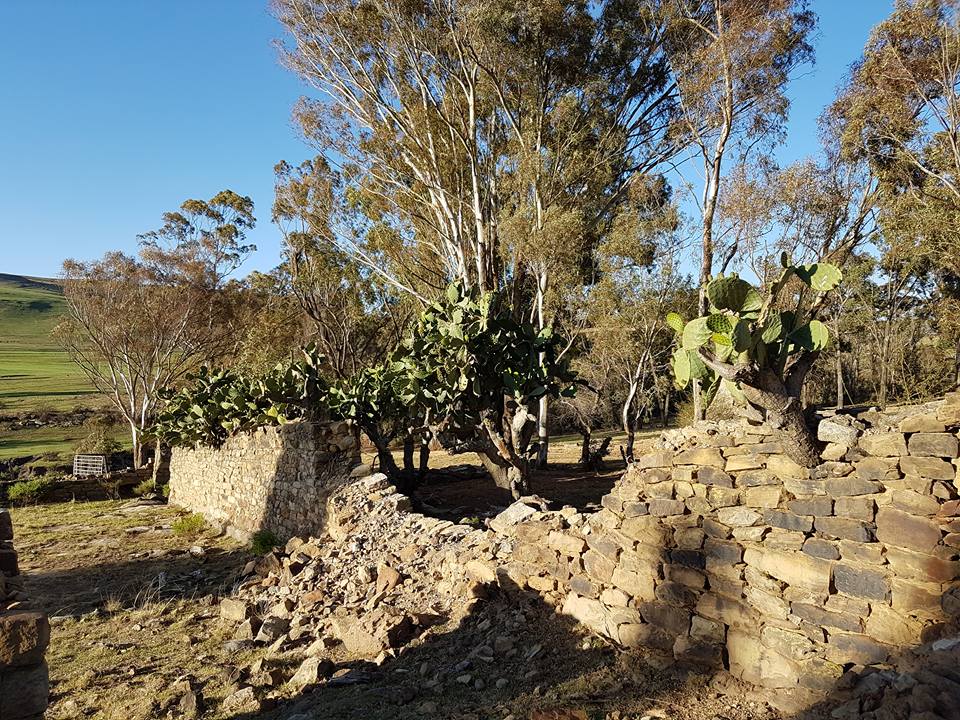
It has wooded kloofs, filled with ferns and flowers, Agapanthus, Watsonias, Kniphofias, Leonotis, Selago, Phygelius and many others.
Woody patches of Leucosidea, Buddleia, Kiggelaria, Polygala, Heteromorpha and Rhus shrubs, as well as the indigenous Mountain Bamboo Thamnocalamus, tessellates, grow along the base of the cliffs. The shrubland vegetation is concentrated on the cool side of Platberg on the sandstone of the Clarens Formation, in gullies, on-screen slopes, mobile boulder beds, and on rocky ridges, Shrubs and trees also occur in a riparian habitat in the south-facing cleft, in which the only road ascends steeply to the summit. An occasional Yellowwood, a sad relic of the many that once flourished here, can be found.
The Rhodesian Flame Lilly (Lithonia Modesta) is a climbing perennial of up to 1 meter. It is found in tall grass on forest margin at 4800feet. It flowers in January and is very rare and is protected in KwaZulu-Natal. What makes this lily so exceptional is that it has also been found on the back slopes of Platberg.
The waterfalls during the rainy season
Many passes are running through the mountain.
The most popular pass is called One Mans Pass, so-called because from a distance an isolated column of rocks standing out against the skyline presents the appearance of a single person standing upright. Up this Pass lies the route for those taking part in the annual mountain race held each October.

Zig-Zag Pass holds a romantic tale used to be told of a large rock, roughly four feet square, which could be seen at the foot of the Zig-Zag pass, a little towards the west. On it, the words ‘Iris Isabelle” was deeply cut. The story ran that a newcomer in this country climbed up and down the Pass and them, wearied out, fell asleep in the shadow of the rock. As he slept he dreamed of the girl he left behind and on waking he carved her name in the rock. But the Isabelle Rock, as it was called is now no more seen. It was probably crushed for use when the mountain Drive was first made in about 1925. The Zig Zag pass is visible just right of the Z-shaped rock formation and was utilized to descend from the mountain.

The longest and the easiest is the Donkey Pass. It was previously known as the Flat Rock Pass which leads up to the huge Robert Gibson Dam, near the eastern end of the mountain. In the past farmers would hire grazing on the summit and the story is told of a tremendous storm which burst on the summit and caused a herd of some thirty cattle to move before it. As still heavier sheets of rain fell the animals quickened their pace to escape. Moving blindly towards the edge of the cliff they fell to their death on the rocks 200 feet below. As the leaders felt the irresistible pressure of those behind them.

The Donkey pass which was constructed in the early 1900s using donkeys – which is where it got its name from, consists of two concrete strips, with a radical 3 km ascent. From the onset, due to its steepness, the Donkey Pass is only accessible via four-wheel-drive vehicles & equipment. When you look back from the top, this pass beautifully frames the glittering Sterkfontein Dam & Drakensberg Mountains.
Die Khyber pass reminds of the sight of a gun. It was named after the Khyber pas in India.
The acting Governor, HF Wilson and his sister came to plant the first trees and suggested that the plantation should be called the Alexandra Forest after the Queen. The suggestion was adopted but the name was never in general use it was better known as the Government Forestry. On this occasion, tea was served in the area set aside for the nursery and many years afterwards townspeople were allowed to make fires there and have picnics and move freely about the whole area.
Seeds of the trees came from the Cape, Transvaal Europe and the United State of America, Australia and Paris, France. 38 varieties were planted. Within 3 years the whole area had been divided into 12-acre blocks with wagon roads between, fences had been put up, pipes or drains laid down and a dam made. By 1920 a quarter of a million trees had been planted in the streets, the Park, the Golf course and the commonage, at the Old Homestead, to the Gymkhana and the polo clubs and the SA Railways.

In the early days, picnics were very popular. Perhaps because houses were not very comfortable, and had few of the conveniences which today are considered essentials, the early inhabitants of the town found that one of their greatest pleasures was getting out-doors and going for picnics. Picnics were often arranged to the “Flat Rock” and people could climb to the Gibson Dam. Akkerbos, near the base of Donkey Pass, is a grove of oak trees that provided a picnic site during a Royal Tour by the British monarchy, including Elizabeth II in 1947.
The Gibson Dam and the Water pans on Platberg
An improvement by the British Military’s Royal Engineers helped to improve the supply of more water to the town. A dam on Platberg, built by the Royal Engineers, was named the Gibson Dam after Mr Gibson, a member of the town board. The wall of the dam was subsequently raised three times thereby increasing its capacity to 540 million litres. The main water reservoirs were constructed in 1904 on the highest point on King’s Hill. Water was pumped from the stream which flows through the then Botanic Gardens. From the reservoir, it flowed downhill to the buildings on King’s Hill. The reservoir foundation stone is seen between the two reservoirs.
The water supply of the town, which is always an important matter, was obtained from springs and surface water collected in the upland basins of the Platberg. The water flowed down the cliff through a deep Krantz and forms a clear mountain stream, which passed through bush and over basalt boulders to the town reservoirs. The large dam The Platberg dam with a wall 200ft long 9ft high and capable of impounding 120 million gallons of water was built by the Royal Engineers and completed in 1904. An account of 386GBP was presented to the council of Harrismith.
Hawkins and Von During Dams – The dam was built in 1899 and named after Captain Harlan Hawkins. He was also in command of “Harrismith Volunteer Light Horse” from 1914 to 1918.
In the last years of the century, the Council once again took thought for the water supply of the town and planned a storage dam. This dam is today known as the Von During Dam, after a very popular mayor in office long after its construction, but it was felt desirable for him to have a memorial of some sort.
Mr Hawkins was responsible for making the dam and pointed out to the Council that a second dam high up the stream could be built. His suggestion was adopted and the present Hawkins dam came into being
Blockhouse still stands guard over the Dams
During 1963 water was brought to the town via water furrow. This changed in July 1877 when the furrow was paved with sandstone.
 |
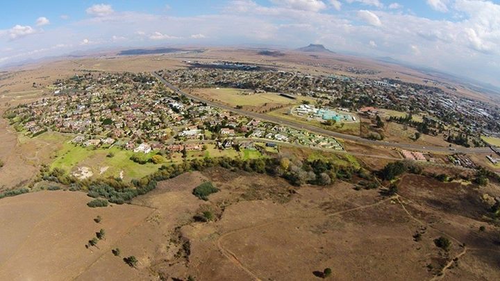
| Jono Skypictures showing Platberg and the town of Harrismith |
Thanks to Biebie de Vos for his pictures of our beautiful mountain.
Thanks to Adam Truscott for the painting
Thanks to Dan Wessels for the beautiful fauna pictures.
Till next time
Hennie & Sandra