 |
An old photo of Vryburg in 1895 showing the staff housing.  |
When the train leaves Vryburg station toward Mahikeng (Mafeking) there is a couple of stations and whistle stops en-route. Today there is not much going on, on this route as the trains that use this line is transporting loads to neighbouring countries of South Africa. We have travelled on the old service road between Paradise and Madibogo to have a look at the marker boards.

First stop is Paradise. There was not a station but the farmers would leave a parcel at the rail side for transportation to the next place. The marker telling us that Paradise is 781 miles from Cape Town and the 4013ft above sea level.
 | |
| Devondale in 1895 |

The next station is Devondale. There used to be water tanks for the steam locomotives. There used to be a little shop built of stone and we would travel on the passenger train from Kameel to Devondale for an outing. The Devondale marker reads 790 miles from Cape Town and 4129ft above sea level.

ext up is Mnyani only 5 miles from Devondale. This stop was used for passengers to get a way of transportation. It was also a popular stop for parcels. The maker reads 795 miles from Cape Town and the altitude is 4207ft. As you will notice there is a climb in the altitude of 194ft over 14 miles.

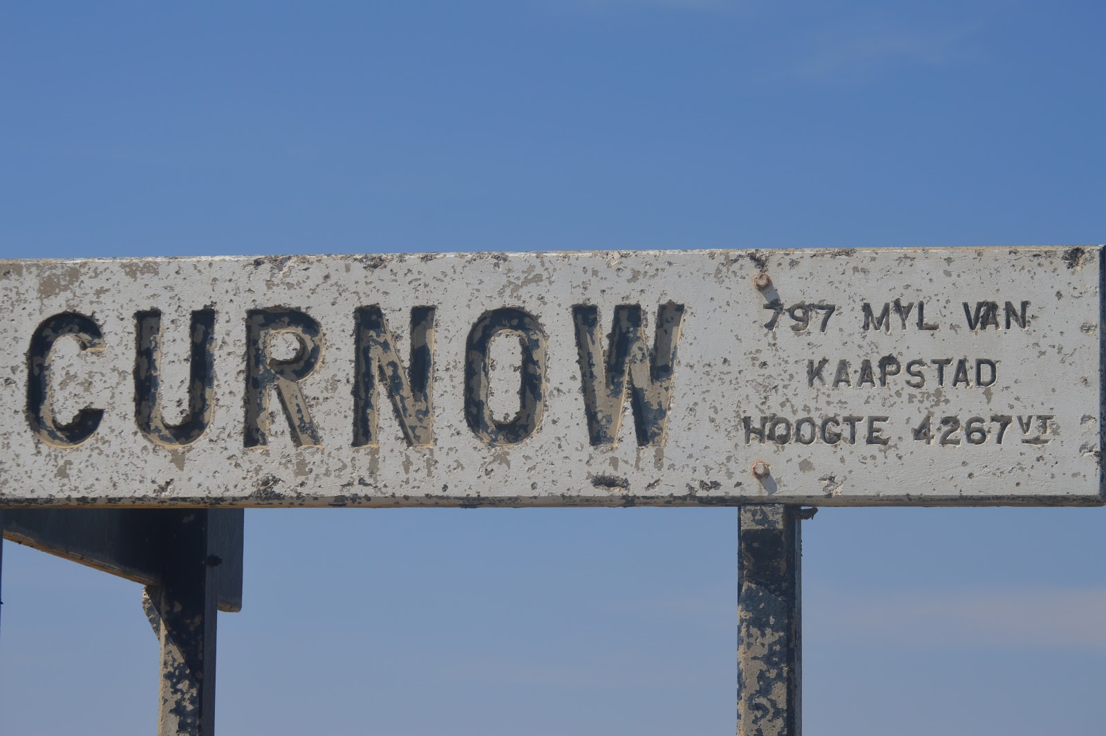
Curnow used to be a whistle-stop like Mnyani. It was a popular place for passengers to make use of the train to travel to Mahikeng on the passenger train. As children, we would call this the milk stop. Farmers would load the milk on the train to be transported to Vryburg to the diary. 797 miles from Cape Town 4267ft above sea level.
The next station is Kameel and it is the station we call home. Kameel used to be a busy station with lots of rail traffic. Today the old rail lines tell the stories of better times. It was the station where the grain from the silos was loaded for the next destination. It was extended with more rail tracks round 1980. The station was also equipped with yard lights. Unfortunately, like so many railway stations, the station building and other buildings were demolished. We still have some fun when the weekly train passes by and you feel the rumble of the train under your feet. It will never be the same again but we are trying our best to uplift the station houses and the community. Kameel is 805 miles from Cape Town 4449ft above sea level.


Still, en-route to Mahikeng is Doornbult. Doornbult is a crossing and between Kameel and Doornbult was the old trolley stop. When a train approached the trolley will have a place to park next to the main line. During the Anglo-Boer War, there was also a corrugated iron blockhouse from where the British troops would protect the railway line. Doornbult is 809 miles from Cape Town and the altitude is 4470ft. This is the highest point on the railway line.


 |
| Thank you to Hannetjie Schoeman for sharing this photo |
Wirsing is a railroad siding and is located in Ngaka Modiri Molema District Municipality, North-West, South Africa. The estimate terrain elevation above sea level is 1377 metres.
Next up is Rabatho. Rabatho is 819miles from Cape Town and the altitude 4325ft

At the end of our road is Madibogo. Like Kameel Madibogo was a busy station. 821 miles from Cape Town 4038ft above sea level. The water tank is still standing the station buildings has been utilized and forms part of the community.


Thank you to everyone who made their photo’s available.
Till next time
Sandra
No comments:
Post a Comment