Harrismith is known for the life that the inhabitants live at the foot of Platberg.
 |
| The Platberg, the Free State’s own “Table Mountain”, overlooks the town of Harrismith. It literally means the flat-mountain. A high inselberg is a landmark & forms an imposing backdrop to the town. It is an extension of the eastern foothills of the Drakensberg Mountains |
 |
| The location of the town and the surroundings tells us that there is more. |
 |
| Loskop is an isolated peak where you will find a huge, shallow pan. In front is Staffordshire Hill and the Grant Quarries |
 |
| Slightly behind Loskop and further north, is Glen Paul. On top there is an odd rock formation like a crab's nipper standing up against the sky. |
 |
| Beside Glen Paul on a lower plateau, Bobbejaankop and Everest and Mooihoek (previously known as Wesselskop) with its lower offshoot Tafelberg. The locals call this group of mountains The Bull, the Cow and the Calf. |
 |
| Verkykerskop |
 |
| Mount Everest |
 |
| North East lies Nelson's Kop, on which a broken portion of the cliff bears a noticeable resemblance to the profile of Admiral Nelson wearing a naval cap. There is the wonderful story of Nelson's Kop that was named after the horse Nelson that was killed by a lion. |
 |
| Very close to it is Tandjesberg, whose rocky crown of boulders looks like a set of false teeth. |
These two mountains, along with five others stretching over a vast area and ending with Mont Pelaan.
This range is known as the Seven Sisters.
 |
| The photo was taken by Dirk Boukaert and we would like to thank him for the beautiful panorama of the mountains. |
 |
| Thanks you to Johan Lodewyk Marais for sharing this panorama. Pilaan, Skeurklip, Waterkop, Tandjiesberg, Nelson's Kop, Rensburgkop, Platberg, Mount Everest and Verkykerskop |
 |
| Mabethlaan |
 |
| Rensburg's Kop with the double humped summit near Swinburne. Very close to Rensburg'skop is the Whispering Mountain and Tintwa Inyoni (haunted by birds) and Verloren Vallei. Leon Strachan shared the following : this picture is much more interesting than it looks. The gap on top of Rensburgskop is not attributed to normal erosion patterns. It is a rare geological phenomenon, a primeval valley, with typical valley profile, in which a river ran many millions of moons ago before the area around the kop eroded at a faster tempo. |
 |
| Tintwa Inyoni |
 |
| Verloren Vallei |
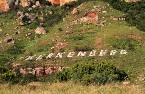 |
| Kerkenberg, for here Piet Retief's followers held a thanksgiving service. |
 |
| Baker's Kop |
 |
| Baker's Kop is a fairly isolated peak with a huge overhang at the foot, which is big enough to house 300 - 400 sheep. Above the cliff is a large cave, inaccessible except with the help of a rope, and even then it is dangerous as the floor of the cave slopes out. |
 |
| Not far from Baker's Kop is Mount Paul. At its foot is a huge boulder beside which the Badenhorst family camped on their arrival in this district and we were told that they have carved their names and some dates. |
 |
| 42nd Hill was previously known as Reitzheuwel |
 |
| The Turkey cave visible on Platberg |
The Story of Harrismith by EB Hawkins
Till next time
Till next time
Sandra